Building a new community
variation 1 to plan change 33: tauriko west NOW OPERATIVE
Tauranga City Council made their decisions on the recommendations from the Independent Hearing Panel on Variation 1 on Monday 3 March 2025. The Council decision is to accept all the panel’s recommendations. In accordance with clauses 103 and 20(1) of Schedule 1 of the RMA, Variation 1 became operative on 17 March 2025. The City Plan has been updated to include the Independent Hearing Panel recommendations and Council decision.
The vision for Tauriko West is to create a thriving community for locals to live, learn, work and play locally. This means the community will have amenities such as schools, parks, cycle and walkways, access to shopping and community facilities, and safe transport connections
Building the new community at Tauriko West required changes to the Tauranga City Plan to rezone the land from rural to urban so housing can be developed (see information on planning process below). Underpinning this is a proposed structure plan for the new community, which shows the new infrastructure required, and where the key elements of the new community would be located. Geotechnical, stormwater, cultural and environmental assessments have been completed to inform this planning.
Most of the land at Tauriko West is owned by Kāinga Ora, Tauriko West Limited (Element IMF), and the Tauriko Property Group with Classic Group, along with some smaller landowners. The three main landowners are contributing to the cost of improvements to SH29 (the Tauriko Enabling Works) to open the area for housing development. Within the new community the developers will deliver a range of housing choice, styles and densities along with internal roads and water/wastewater infrastructure, neighbourhood reserves and local commercial centres.
Tauranga City Council is planning to build a new community centre and library as part of the new community, and work with the developers to deliver a significant reserve along the Wairoa River. The Ministry of Education is working on opportunities to relocate and expand Tauriko School to support current and future communities’ needs, and considering options for a new high school in the growth area.
proposals for the new community:
- A range of housing choice, styles and densities
- A local centre – providing for a collection of several shops and services including opportunities for a small (convenience) supermarket, GP surgery, pharmacy, café, takeaway, and possibly public toilets; and up to two smaller-scale, neighbourhood centres for local shops (day-to-day goods).
- A Wairoa River Reserve – with a playground, access to the river, walkways along the length of the full river corridor and water access (within Tauriko West); and which celebrates the historic and cultural importance of the awa (river)
- Integrated neighbourhood parks and other open space
- A community centre and library (‘Suburban Hub Centre’)
- A relocated and expanded school supporting current and future communities’ needs
- Potential for a new high school.
- Recognition of sites of cultural significance to mana whenua, seeking to preserve and enhance those areas
- Looking after our waterways and wetlands
- Connectivity through street design and open space planning
- A road network that promotes sustainable modes of transport such as walking, cycling and public transport
- Multimodal links to Tauriko Business Estate, Tauranga Crossing, and the wider city.
The vision document below was drawn up as part of the development of the plan change and structure plan, and shows what Tauriko West could look like.
Tauriko West vision document (8.6mb pdf)
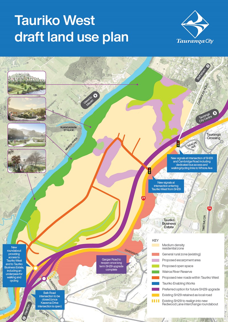
Draft Land use plan for Tauriko west
Tauranga City Council has developed a draft land use plan for Tauriko West which shows where the key elements of the new community could be located.
The draft land use plan shows the extent of land that may be developed for residential use, along with:
- Riverside reserve, escarpment areas, and open space
- Connections to the short and long-term transport improvements
- Multimodal links to Tauriko Business Estate and the wider city
- Opportunities to connect walkways/cycleways along the Wairoa River.
Tauriko West draft land use plan
Densities in these new communities are expected to be at least 25 dwellings per hectare in the first 10 years and will reach higher densities over time.
THe wairoa River
The Wairoa River is a special natural and cultural landmark of the area. The plan change put in place zoning and provisions which embrace the significance of the river and seek to protect the awa while providing access for everyone to enjoy this special environment.
Through the development of Tauriko West, we propose to:
- Maintain and enhance the landscape of the river margin
- Celebrate the historic and cultural importance of the awa
- Recognise sites of cultural significance to mana whenua and preserve and enhance those areas
- Provide for open and generous public access to and along the river frontage through to Bethlehem
- Enhance connectivity to the river by providing east-west active street links to the river throughout the development
- Enable the integration of new urban development set back from the river margin
- Manage stormwater runoff from urban development.
The Planning Process
Building the new community at Tauriko West requires changes to the Tauranga City Plan, to rezone the previously rural-zoned land and allow housing to be developed. The plan change also serves to outline the planning rules that will apply to the development, and guide consent decisions.
The proposed Tauriko West plan change was publicly notified in March 2024 through a variation to Plan Change 33: Enabling Housing Supply, and a hearing was held in December 2024 by the appointed Independent Hearing Panel, who then prepared their recommendations to Council on that basis.
Find out more about the variation
On 3 March 2025 the Tauranga City Mayor and Councillors accepted all the recommendations of the Independent Hearing Panel. The adoption of the Tauriko West plan change represents a significant step forward in shaping the future of the community, and of the city. The changes were made operative in the City Plan on 17 March 2025 and will now guide future development in Tauriko West.
Other processes required to be completed before development can start include council’s application for a Comprehensive Stormwater Consent, the developers obtaining consents for bulk earthworks, and council finalising developer agreements. These processes are all underway. It is expected
Preliminary Processes
To prepare for the rezoning of Tauriko West, the change to the urban limits line (Bay of Plenty Regional Council) and local government boundary alteration (Western Bay of Plenty District Council) have been completed.
Change 4 (Tauriko West Urban Limit) to the Bay of Plenty Regional Policy Statement (RPS) was incorporated into the RPS and operative from 30 October 2018. It amended the current Urban Limit and indicative timing of growth to provide for the development of Tauriko West.
Find out more about the Regional Policy Statement.
The local government boundary alteration took effect on 1 January 2021, and shifted all of the land at Tauriko West into Tauranga City Council’s jurisdiction.
Find out more about the Local Government Commission’s process.
Find out more on the role of Western Bay of Plenty District Council in making the original application.
Sign up for our email updates
Throughout the process we will be going out to the community and stakeholders to provide information and gather ideas and feedback. This will include open days and workshops, surveys and regular updates via mail, email and on this website.